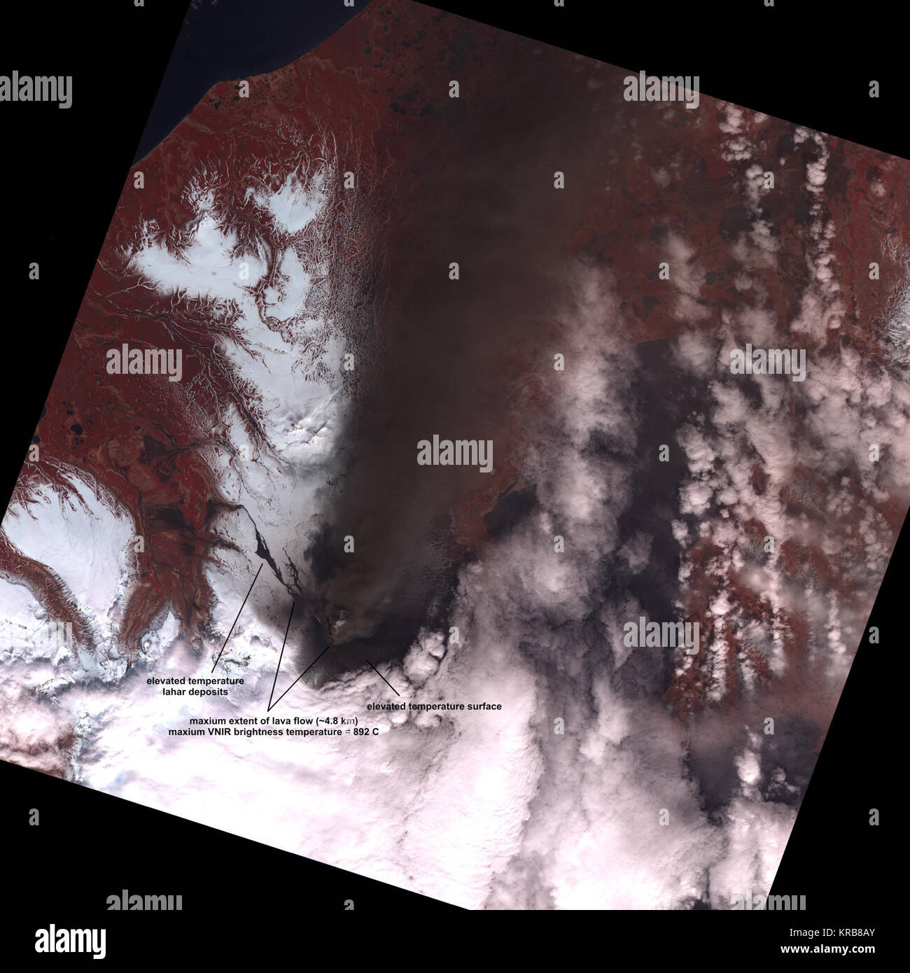
Visible and near infrared ASTER satellite image of Pavlof Volcano, acquired 1410 AKDT (2210 UTC) May 19, 2013. ASTER (Advanced Spaceborne Thermal Emission and Reflection Radiometer) is a high resolution imaging instrument that is flying on the Terra satellite. This image is 60 km (37 miles) edge-to-edge. The max brightness temperature is near 900 degrees Celsius (1600 Fahrenheit) at the vent, and the lava flow is 4.8 km (3 miles) long. Also shown are ash or mud flow deposits to the southeast and northwest of the crater. Credit: Mike Ramsey and the University of Pittsburgh. -- The Pavlof v
Image details
Contributor:
NASA Image Collection / Alamy Stock PhotoImage ID:
KRB8AYFile size:
7.2 MB (338.2 KB Compressed download)Releases:
Model - no | Property - noDo I need a release?Dimensions:
1581 x 1581 px | 26.8 x 26.8 cm | 10.5 x 10.5 inches | 150dpiDate taken:
24 May 2013More information:
This image is a public domain image, which means either that copyright has expired in the image or the copyright holder has waived their copyright. Alamy charges you a fee for access to the high resolution copy of the image.
This image could have imperfections as it’s either historical or reportage.
Visible and near infrared ASTER satellite image of Pavlof Volcano, acquired 1410 AKDT (2210 UTC) May 19, 2013. ASTER (Advanced Spaceborne Thermal Emission and Reflection Radiometer) is a high resolution imaging instrument that is flying on the Terra satellite. This image is 60 km (~37 miles) edge-to-edge. The max brightness temperature is near 900 degrees Celsius (1600 Fahrenheit) at the vent, and the lava flow is 4.8 km (3 miles) long. Also shown are ash or mud flow deposits to the southeast and northwest of the crater. Credit: Mike Ramsey and the University of Pittsburgh. -- The Pavlof volcano, located in the Alaska Peninsula National Wildlife Refuge has been producing steam and gas plumes since May 13. The volcano's plumes were captured by NASA satellite imagery and photographs taken by the astronauts aboard the International Space Station. The Pavlof volcano is located about 625 miles (1, 000 kilometers) southwest of Anchorage, Alaska. Astronauts aboard the International Space Station captured stunning photos of Pavlof’s eruption on May 18, and the next day, the Moderate Resolution Imaging Spectroradiometer or MODIS instrument that flies aboard NASA’s Aqua and Terra satellites captured different views of the ash plume. The ASTER (Advanced Spaceborne Thermal Emission and Reflection Radiometer) instrument that also flies aboard NASA's Terra satellite, provided a look at the temperatures and lava flow from the eruption. The Terra MODIS image was taken on May 19 at 2:10 p.m. AKDT local time (6:10 p.m. EDT) and showed the area of heat from the volcano as well as the ash plume. The ash plume appeared as a dark brown color, blowing in a northerly direction for about 30 miles. At that time the ash cloud was about 20, 000 feet above sea level. The ASTER instrument is a high resolution imaging instrument that is flying on the Terra satellite. ASTER captured a visible and near infrared image of Pavlof Volcano at 2:10 p.m. AKDT local time (6:10 p.m. EDT)