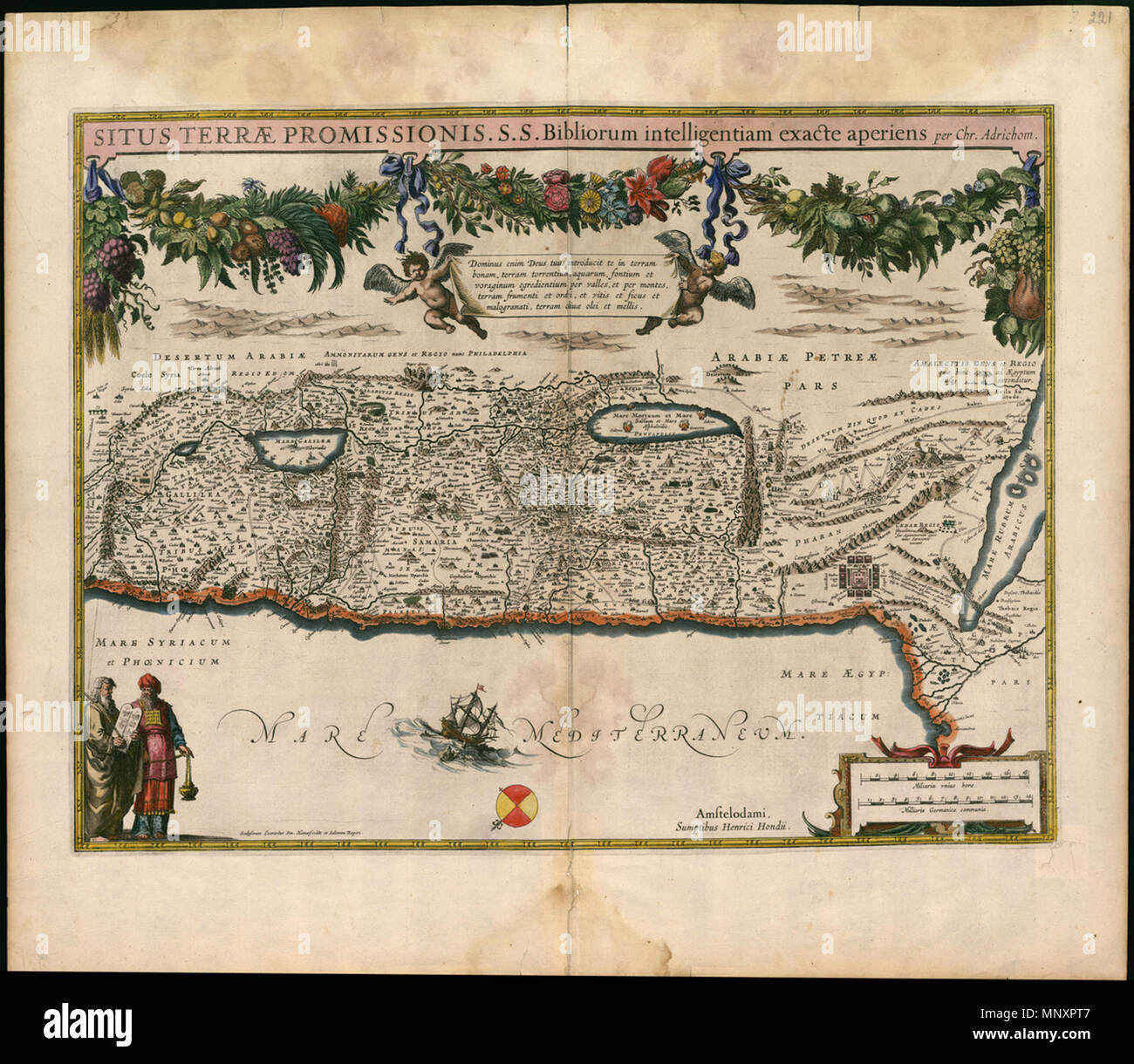
Русский: Расположение Земли Обетованной в точности отражает знание Священного Писания Français : La Situation de la terre promise révèle une connaissance approfondie de la Bible English: The Situation of the Promised Land Accurately Reveals a Knowledge of the Holy Bible 中文: 乐土的情形准确揭示了对圣经的认识 Português: O Situação da Terra Prometida Revela adequadamente o conhecimento da Bíblia Sagrada العربية: موقع أرض الميعاد يكشف بدقة عن معرفة الكتاب المقدس Español: La ubicación precisa de la Tierra Prometida revela el conocimiento de la Santa Biblia . Русский: Эта медная гравюра Святой Земли является первой
Image details
Contributor:
The Picture Art Collection / Alamy Stock PhotoImage ID:
MNXPT7File size:
14.3 MB (906.6 KB Compressed download)Releases:
Model - no | Property - noDo I need a release?Dimensions:
2397 x 2085 px | 40.6 x 35.3 cm | 16 x 13.9 inches | 150dpiMore information:
This image is a public domain image, which means either that copyright has expired in the image or the copyright holder has waived their copyright. Alamy charges you a fee for access to the high resolution copy of the image.
This image could have imperfections as it’s either historical or reportage.
Русский: Расположение Земли Обетованной в точности отражает знание Священного Писания Français : La Situation de la terre promise révèle une connaissance approfondie de la Bible English: The Situation of the Promised Land Accurately Reveals a Knowledge of the Holy Bible 中文: 乐土的情形准确揭示了对圣经的认识 Português: O Situação da Terra Prometida Revela adequadamente o conhecimento da Bíblia Sagrada العربية: موقع أرض الميعاد يكشف بدقة عن معرفة الكتاب المقدس Español: La ubicación precisa de la Tierra Prometida revela el conocimiento de la Santa Biblia . Русский: Эта медная гравюра Святой Земли является первой гравюрой из цикла переизданий карты Кристиана ван Адрихема (1533-1585 гг.), осуществленных голландскими издателями XVII века. Адрихем был римско-католическим священником и библеистом. На своей карте Адрихем изобразил Святую Землю так, как представлял ее на основании библейских исследований. Карта была издана в Амстердаме в 1633 году Хенриком Хондиусом (1597-1651 гг.), а затем ее включили в новое издание 'Atlas ou representation du monde universel' ('Атласа или универсального изображения мира'), которое было впервые опубликовано Йодокусом Хондиусом (1563-1612 гг.) и Герхардом Меркатором (1512-1594 гг.). Français : Cette gravure sur cuivre de la Terre sainte est la première d'une série de reimpressions d'une carte de Christiaan van Adri