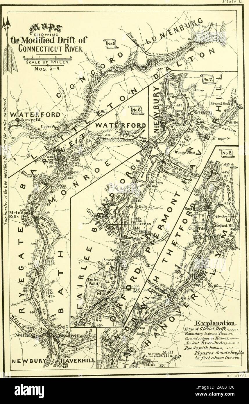
. The geology of New Hampshire : a report comprising the results of explorations ordered by the legislature. The noticeable features of the valley in this distance are, that it is deepand narrow, with sloping sides of till, and destitute of the level alluvialterraces and intervals which occupy a large width everywhere else alongthe river. Where any modified drift does occur, it is coarser than usual,being generally gravel, sometimes imperfectly rounded or water-worn, andits surface has commonly an irregular slope. The upper portion of theserapids is especially destitute even of such alluvial d
Image details
Contributor:
The Reading Room / Alamy Stock PhotoImage ID:
2AG3TD0File size:
7.2 MB (628.8 KB Compressed download)Releases:
Model - no | Property - noDo I need a release?Dimensions:
1284 x 1947 px | 21.7 x 33 cm | 8.6 x 13 inches | 150dpiMore information:
This image is a public domain image, which means either that copyright has expired in the image or the copyright holder has waived their copyright. Alamy charges you a fee for access to the high resolution copy of the image.
This image could have imperfections as it’s either historical or reportage.
. The geology of New Hampshire : a report comprising the results of explorations ordered by the legislature. The noticeable features of the valley in this distance are, that it is deepand narrow, with sloping sides of till, and destitute of the level alluvialterraces and intervals which occupy a large width everywhere else alongthe river. Where any modified drift does occur, it is coarser than usual, being generally gravel, sometimes imperfectly rounded or water-worn, andits surface has commonly an irregular slope. The upper portion of theserapids is especially destitute even of such alluvial deposits, the highest•that occur being from 60 to 75 feet above the stream. It is frequentlyevident that the source of these deposits is not the main river, but a trib-utary, as in the case of Niles stream in Concord, Vt., and on both sidesat Upper Waterford. These deltas are greater in height, as well as inamount, than the scanty remnants of the alluvium of the main valley. On the lower portion of these rapids the modified drift appears ingreater quantity and at a much increased height. Opposite Lower. MODIFIED DRIFT ALONG CONNECTICUT RIVER. 2$ Waterford we find irregular hillocks of sand, barren of vegetation, anddrifted by the wind, the highest of which are about 200 feet above theriver. Below this point the modified drift rises in irregular slopes to aheight of 200 feet in several places, and its position shows it to have beenprincipally deposited from currents of the main valley. As we approachthe foot of the falls its coarse character is changed, and sand predomi-nates in the place of gravel. These deposits probably once filled thispart of the valley nearly 200 feet above the present river, sloping in sixmiles between Lower Waterford and Passumpsic river from about 800 to650 feet above the sea. The course of the river along Fifteen-miles falls is S. 70° W., beingturned much to the west from its general direction. This course is atright angles to the line of motion of th