···
Prince Edward Island, Maritime province of Canada, political map Image details More information:
Prince Edward Island, Maritime and Atlantic province of Canada, political map. The Island, located in the Gulf of St. Lawrence, bordered to New Brunswick and Nova Scotia, with capital Charlottetown.
Search stock photos by tags
Similar stock vectors Map of Prince Edward Island Stock Vector https://www.alamy.com/licenses-and-pricing/?v=1 https://www.alamy.com/stock-photo-map-of-prince-edward-island-126684942.html RF HA2YX6 – Map of Prince Edward Island Vector color editable map of Atlantic provinces of Canada New Brunswick, Nova Scotia, Prince Edward Island and province of Newfoundland with capitals, Stock Vector https://www.alamy.com/licenses-and-pricing/?v=1 https://www.alamy.com/vector-color-editable-map-of-atlantic-provinces-of-canada-new-brunswick-nova-scotia-prince-edward-island-and-province-of-newfoundland-with-capitals-image402123702.html RF 2EA68TP – Vector color editable map of Atlantic provinces of Canada New Brunswick, Nova Scotia, Prince Edward Island and province of Newfoundland with capitals, Prince Edward Island, territory of Canada, Canadian province. Vector travel plate, vintage sign, retro postcard design. Old plaque with oak tree leaves and branches, royal crown and flag Stock Vector https://www.alamy.com/licenses-and-pricing/?v=1 https://www.alamy.com/prince-edward-island-territory-of-canada-canadian-province-vector-travel-plate-vintage-sign-retro-postcard-design-old-plaque-with-oak-tree-leaves-and-branches-royal-crown-and-flag-image600289267.html RF 2WTHF2B – Prince Edward Island, territory of Canada, Canadian province. Vector travel plate, vintage sign, retro postcard design. Old plaque with oak tree leaves and branches, royal crown and flag The Maritimes region location within Canada 3d isometric map Stock Vector https://www.alamy.com/licenses-and-pricing/?v=1 https://www.alamy.com/the-maritimes-region-location-within-canada-3d-isometric-map-image543257392.html RF 2PFRE9M – The Maritimes region location within Canada 3d isometric map Prince Edward Island, Maritime province of Canada, gray political map Stock Vector https://www.alamy.com/licenses-and-pricing/?v=1 https://www.alamy.com/prince-edward-island-maritime-province-of-canada-gray-political-map-image549113202.html RF 2PWA7DP – Prince Edward Island, Maritime province of Canada, gray political map Prince Edward Island, Saskatchewan and Alberta Canadian provinces and regions. Vector plates with flags of Canada provinces, prairie lily, oak tree le Stock Vector https://www.alamy.com/licenses-and-pricing/?v=1 https://www.alamy.com/prince-edward-island-saskatchewan-and-alberta-canadian-provinces-and-regions-vector-plates-with-flags-of-canada-provinces-prairie-lily-oak-tree-le-image426262359.html RF 2FNDWYK – Prince Edward Island, Saskatchewan and Alberta Canadian provinces and regions. Vector plates with flags of Canada provinces, prairie lily, oak tree le New Brunswick, Maritime and Atlantic province of Canada, political map Stock Vector https://www.alamy.com/licenses-and-pricing/?v=1 https://www.alamy.com/new-brunswick-maritime-and-atlantic-province-of-canada-political-map-image549042302.html RF 2PW711J – New Brunswick, Maritime and Atlantic province of Canada, political map New Brunswick, Maritime and Atlantic province of Canada, gray political map Stock Vector https://www.alamy.com/licenses-and-pricing/?v=1 https://www.alamy.com/new-brunswick-maritime-and-atlantic-province-of-canada-gray-political-map-image549111094.html RF 2PWA4PE – New Brunswick, Maritime and Atlantic province of Canada, gray political map Nova Scotia, Maritime and Atlantic province of Canada, political map Stock Vector https://www.alamy.com/licenses-and-pricing/?v=1 https://www.alamy.com/nova-scotia-maritime-and-atlantic-province-of-canada-political-map-image549077613.html RF 2PW8J2N – Nova Scotia, Maritime and Atlantic province of Canada, political map Nova Scotia, Maritime and Atlantic province of Canada, gray political map Stock Vector https://www.alamy.com/licenses-and-pricing/?v=1 https://www.alamy.com/nova-scotia-maritime-and-atlantic-province-of-canada-gray-political-map-image549118043.html RF 2PWADJK – Nova Scotia, Maritime and Atlantic province of Canada, gray political map The Maritimes, the Maritime provinces of Eastern Canada, political map Stock Vector https://www.alamy.com/licenses-and-pricing/?v=1 https://www.alamy.com/the-maritimes-the-maritime-provinces-of-eastern-canada-political-map-image549014279.html RF 2PW5N8R – The Maritimes, the Maritime provinces of Eastern Canada, political map The Maritimes region of Eastern Canada, Maritime provinces gray political map Stock Vector https://www.alamy.com/licenses-and-pricing/?v=1 https://www.alamy.com/the-maritimes-region-of-eastern-canada-maritime-provinces-gray-political-map-image549048009.html RF 2PW789D – The Maritimes region of Eastern Canada, Maritime provinces gray political map 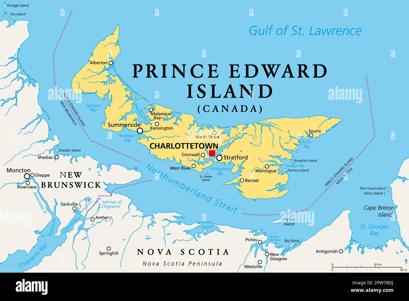