···
Siege of Aire, 1710, Plan De la Ville d'Aire et de ses Environs (...) Assiegée par les Hauts-Alliés sous le Commandement de Son A.S. Monseigr. le Prince d'Anhalt Dessau (...) Prise le 8. Novembre 1710 (...) (title on object), Map of the siege of the city of Aire with the wide surroundings, besieged from September 11 and taken by the Allies under the Prince of Anhalt-Dessau on November 8, 1710. Bottom right a cartouche with the legend A-S in French. Part of a bundled collection of plans of battles and cities renowned in the War of the Spanish Succession., print maker: J.G. Harrewijn (II) ( Image details File size:
65 MB (6.1 MB Compressed download)
Open your image file to the full size using image processing software.
Dimensions:
5352 x 4245 px | 45.3 x 35.9 cm | 17.8 x 14.2 inches | 300dpi
More information:
This image could have imperfections as it’s either historical or reportage.
Search stock photos by tags
Similar stock images Inspired by Siege of Aire, 1710, Plan de la ville d'Aire et du Fort St. François Et de ses trois Attaques (...) Assiégée par les Hauts Alliés (...) 1710, Map of the siege of the town of Aire with Fort St. François, besieged from September 11 and taken by the Allies under the Prince of Anhalt-Dessau, Reimagined by Artotop. Classic art reinvented with a modern twist. Design of warm cheerful glowing of brightness and light ray radiance. Photography inspired by surrealism and futurism, embracing dynamic energy of modern technology, movement, speed and revolutionize culture Stock Photo https://www.alamy.com/licenses-and-pricing/?v=1 https://www.alamy.com/inspired-by-siege-of-aire-1710-plan-de-la-ville-daire-et-du-fort-st-franois-et-de-ses-trois-attaques-assige-par-les-hauts-allis-1710-map-of-the-siege-of-the-town-of-aire-with-fort-st-franois-besieged-from-september-11-and-taken-by-the-allies-under-the-prince-of-anhalt-dessau-reimagined-by-artotop-classic-art-reinvented-with-a-modern-twist-design-of-warm-cheerful-glowing-of-brightness-and-light-ray-radiance-photography-inspired-by-surrealism-and-futurism-embracing-dynamic-energy-of-modern-technology-movement-speed-and-revolutionize-culture-image459380398.html RF 2HKAGAP – Inspired by Siege of Aire, 1710, Plan de la ville d'Aire et du Fort St. François Et de ses trois Attaques (...) Assiégée par les Hauts Alliés (...) 1710, Map of the siege of the town of Aire with Fort St. François, besieged from September 11 and taken by the Allies under the Prince of Anhalt-Dessau, Reimagined by Artotop. Classic art reinvented with a modern twist. Design of warm cheerful glowing of brightness and light ray radiance. Photography inspired by surrealism and futurism, embracing dynamic energy of modern technology, movement, speed and revolutionize culture Siege of Aire, 1710, Plan de la ville d'Aire et du Fort St. François Et de ses trois Attaques (...) Assiégée par les Hauts Alliés (...) 1710 (title on object), Map of the siege of the town of Aire with Fort St. François, besieged from September 11 and taken by the Allies under the Prince of Anhalt-Dessau on November 8, 1710. Bottom right a cartouche with the legend A-P in French. Part of a bundled collection of plans of battles and cities renowned in the War of the Spanish Succession., print maker: Pieter Devel (mentioned on object), publisher: Eugene Henry Fricx (mentioned on object Stock Photo https://www.alamy.com/licenses-and-pricing/?v=1 https://www.alamy.com/siege-of-aire-1710-plan-de-la-ville-daire-et-du-fort-st-franois-et-de-ses-trois-attaques-assige-par-les-hauts-allis-1710-title-on-object-map-of-the-siege-of-the-town-of-aire-with-fort-st-franois-besieged-from-september-11-and-taken-by-the-allies-under-the-prince-of-anhalt-dessau-on-november-8-1710-bottom-right-a-cartouche-with-the-legend-a-p-in-french-part-of-a-bundled-collection-of-plans-of-battles-and-cities-renowned-in-the-war-of-the-spanish-succession-print-maker-pieter-devel-mentioned-on-object-publisher-eugene-henry-fricx-mentioned-on-object-image454363297.html RM 2HB610H – Siege of Aire, 1710, Plan de la ville d'Aire et du Fort St. François Et de ses trois Attaques (...) Assiégée par les Hauts Alliés (...) 1710 (title on object), Map of the siege of the town of Aire with Fort St. François, besieged from September 11 and taken by the Allies under the Prince of Anhalt-Dessau on November 8, 1710. Bottom right a cartouche with the legend A-P in French. Part of a bundled collection of plans of battles and cities renowned in the War of the Spanish Succession., print maker: Pieter Devel (mentioned on object), publisher: Eugene Henry Fricx (mentioned on object Siege from Aire, 1710; Plan De La Ville d'Aire et du Fort St. François (...). Map of Aire, Bestorped and taken by the Allies on November 8, 1710. At the bottom right of a cartouche with the legend A-V in French. Stock Photo https://www.alamy.com/licenses-and-pricing/?v=1 https://www.alamy.com/siege-from-aire-1710-plan-de-la-ville-daire-et-du-fort-st-franois-map-of-aire-bestorped-and-taken-by-the-allies-on-november-8-1710-at-the-bottom-right-of-a-cartouche-with-the-legend-a-v-in-french-image430236612.html RM 2FYXY58 – Siege from Aire, 1710; Plan De La Ville d'Aire et du Fort St. François (...). Map of Aire, Bestorped and taken by the Allies on November 8, 1710. At the bottom right of a cartouche with the legend A-V in French. Siege from Aire, 1710; Plan de la Ville d'Aire et du Fort St. François et de Ses Trois Attaques (...) Assiégée Par les Hauts Alliés (...) 1710. Map of the town of the city of Aire with the Fort St. François, BESTED from September 11 and taken by the Allies under the prince of Anhalt-Dessau on November 8, 1710. At the bottom right a cartouche with the legend AP in French. Part of a bundled collection of plans of battles and cities renowned in the Spanish succession war. Stock Photo https://www.alamy.com/licenses-and-pricing/?v=1 https://www.alamy.com/siege-from-aire-1710-plan-de-la-ville-daire-et-du-fort-st-franois-et-de-ses-trois-attaques-assige-par-les-hauts-allis-1710-map-of-the-town-of-the-city-of-aire-with-the-fort-st-franois-bested-from-september-11-and-taken-by-the-allies-under-the-prince-of-anhalt-dessau-on-november-8-1710-at-the-bottom-right-a-cartouche-with-the-legend-ap-in-french-part-of-a-bundled-collection-of-plans-of-battles-and-cities-renowned-in-the-spanish-succession-war-image431590983.html RM 2G24JKK – Siege from Aire, 1710; Plan de la Ville d'Aire et du Fort St. François et de Ses Trois Attaques (...) Assiégée Par les Hauts Alliés (...) 1710. Map of the town of the city of Aire with the Fort St. François, BESTED from September 11 and taken by the Allies under the prince of Anhalt-Dessau on November 8, 1710. At the bottom right a cartouche with the legend AP in French. Part of a bundled collection of plans of battles and cities renowned in the Spanish succession war. Inspired by Siege of Aire, 1710, Plan de la ville d'Aire et du Fort St. François Et de ses trois Attaques (...) Assiégée par les Hauts Alliés (...) 1710, Map of the siege of the town of Aire with Fort St. François, besieged from September 11 and taken by the Allies under the Prince of Anhalt-Dessau, Reimagined by Artotop. Classic art reinvented with a modern twist. Design of warm cheerful glowing of brightness and light ray radiance. Photography inspired by surrealism and futurism, embracing dynamic energy of modern technology, movement, speed and revolutionize culture Stock Photo https://www.alamy.com/licenses-and-pricing/?v=1 https://www.alamy.com/inspired-by-siege-of-aire-1710-plan-de-la-ville-daire-et-du-fort-st-franois-et-de-ses-trois-attaques-assige-par-les-hauts-allis-1710-map-of-the-siege-of-the-town-of-aire-with-fort-st-franois-besieged-from-september-11-and-taken-by-the-allies-under-the-prince-of-anhalt-dessau-reimagined-by-artotop-classic-art-reinvented-with-a-modern-twist-design-of-warm-cheerful-glowing-of-brightness-and-light-ray-radiance-photography-inspired-by-surrealism-and-futurism-embracing-dynamic-energy-of-modern-technology-movement-speed-and-revolutionize-culture-image459379876.html RF 2HKAFM4 – Inspired by Siege of Aire, 1710, Plan de la ville d'Aire et du Fort St. François Et de ses trois Attaques (...) Assiégée par les Hauts Alliés (...) 1710, Map of the siege of the town of Aire with Fort St. François, besieged from September 11 and taken by the Allies under the Prince of Anhalt-Dessau, Reimagined by Artotop. Classic art reinvented with a modern twist. Design of warm cheerful glowing of brightness and light ray radiance. Photography inspired by surrealism and futurism, embracing dynamic energy of modern technology, movement, speed and revolutionize culture Siege of Aire, 1710, Plan de la ville d'Aire et du Fort St. François Et de ses trois Attaques (...) Assiégée par les Hauts Alliés (...) 1710 (title on object), Map of the siege of the town of Aire with Fort St. François, besieged from September 11 and taken by the Allies under the Prince of Anhalt-Dessau on November 8, 1710. Bottom right a cartouche with the legend A-P in French. Part of a bundled collection of plans of battles and cities renowned in the War of the Spanish Succession., print maker: Pieter Devel (mentioned on object), publisher: Eugene Henry Fricx (mentioned on object Stock Photo https://www.alamy.com/licenses-and-pricing/?v=1 https://www.alamy.com/siege-of-aire-1710-plan-de-la-ville-daire-et-du-fort-st-franois-et-de-ses-trois-attaques-assige-par-les-hauts-allis-1710-title-on-object-map-of-the-siege-of-the-town-of-aire-with-fort-st-franois-besieged-from-september-11-and-taken-by-the-allies-under-the-prince-of-anhalt-dessau-on-november-8-1710-bottom-right-a-cartouche-with-the-legend-a-p-in-french-part-of-a-bundled-collection-of-plans-of-battles-and-cities-renowned-in-the-war-of-the-spanish-succession-print-maker-pieter-devel-mentioned-on-object-publisher-eugene-henry-fricx-mentioned-on-object-image454363521.html RM 2HB618H – Siege of Aire, 1710, Plan de la ville d'Aire et du Fort St. François Et de ses trois Attaques (...) Assiégée par les Hauts Alliés (...) 1710 (title on object), Map of the siege of the town of Aire with Fort St. François, besieged from September 11 and taken by the Allies under the Prince of Anhalt-Dessau on November 8, 1710. Bottom right a cartouche with the legend A-P in French. Part of a bundled collection of plans of battles and cities renowned in the War of the Spanish Succession., print maker: Pieter Devel (mentioned on object), publisher: Eugene Henry Fricx (mentioned on object Siege from Aire, 1710; Plan de la Ville d'Aire et du Fort St. François et de Ses Trois Attaques (...) Assiégée Par les Hauts Alliés (...) 1710. Map of the town of the city of Aire with the Fort St. François, BESTED from September 11 and taken by the Allies under the prince of Anhalt-Dessau on November 8, 1710. At the bottom right a cartouche with the legend AP in French. Part of a bundled collection of plans of battles and cities renowned in the Spanish succession war. Stock Photo https://www.alamy.com/licenses-and-pricing/?v=1 https://www.alamy.com/siege-from-aire-1710-plan-de-la-ville-daire-et-du-fort-st-franois-et-de-ses-trois-attaques-assige-par-les-hauts-allis-1710-map-of-the-town-of-the-city-of-aire-with-the-fort-st-franois-bested-from-september-11-and-taken-by-the-allies-under-the-prince-of-anhalt-dessau-on-november-8-1710-at-the-bottom-right-a-cartouche-with-the-legend-ap-in-french-part-of-a-bundled-collection-of-plans-of-battles-and-cities-renowned-in-the-spanish-succession-war-image431580357.html RM 2G24545 – Siege from Aire, 1710; Plan de la Ville d'Aire et du Fort St. François et de Ses Trois Attaques (...) Assiégée Par les Hauts Alliés (...) 1710. Map of the town of the city of Aire with the Fort St. François, BESTED from September 11 and taken by the Allies under the prince of Anhalt-Dessau on November 8, 1710. At the bottom right a cartouche with the legend AP in French. Part of a bundled collection of plans of battles and cities renowned in the Spanish succession war. Inspired by Siege of Aire, 1710, Plan De la Ville d'Aire et de ses Environs (...) Assiegée par les Hauts-Alliés sous le Commandement de Son A.S. Monseigr. le Prince d'Anhalt Dessau (...) Prise le 8. Novembre 1710 (...), Map of the siege of the city of Aire with the wide surroundings, besieged from, Reimagined by Artotop. Classic art reinvented with a modern twist. Design of warm cheerful glowing of brightness and light ray radiance. Photography inspired by surrealism and futurism, embracing dynamic energy of modern technology, movement, speed and revolutionize culture Stock Photo https://www.alamy.com/licenses-and-pricing/?v=1 https://www.alamy.com/inspired-by-siege-of-aire-1710-plan-de-la-ville-daire-et-de-ses-environs-assiege-par-les-hauts-allis-sous-le-commandement-de-son-as-monseigr-le-prince-danhalt-dessau-prise-le-8-novembre-1710-map-of-the-siege-of-the-city-of-aire-with-the-wide-surroundings-besieged-from-reimagined-by-artotop-classic-art-reinvented-with-a-modern-twist-design-of-warm-cheerful-glowing-of-brightness-and-light-ray-radiance-photography-inspired-by-surrealism-and-futurism-embracing-dynamic-energy-of-modern-technology-movement-speed-and-revolutionize-culture-image459380394.html RF 2HKAGAJ – Inspired by Siege of Aire, 1710, Plan De la Ville d'Aire et de ses Environs (...) Assiegée par les Hauts-Alliés sous le Commandement de Son A.S. Monseigr. le Prince d'Anhalt Dessau (...) Prise le 8. Novembre 1710 (...), Map of the siege of the city of Aire with the wide surroundings, besieged from, Reimagined by Artotop. Classic art reinvented with a modern twist. Design of warm cheerful glowing of brightness and light ray radiance. Photography inspired by surrealism and futurism, embracing dynamic energy of modern technology, movement, speed and revolutionize culture Siege of Aire, 1710, Plan de la Ville d'Aire Assiegée par les Alliez under le Commandemt. the S.A.S. Monsr. le Prince d'Anhalt Dessau & Le 8 Novemb. 1710 (title on object), Map of Aire, besieged and captured by the Allies, November 8, 1710. Illustration in the Dutch translation from 1716 by J. Lamigue, Het leven van Zyne Hoogheit Johan Willem Friso, vol. II, p. 208/209., print, print maker: Matthijs Pool, (possibly), after drawing by: Gillius Brakel, (mentioned on object), publisher: Johannes van Oosterwyk, print maker: Northern Netherlands, publisher: Amsterdam, 1714 - 1716, paper, etching Stock Photo https://www.alamy.com/licenses-and-pricing/?v=1 https://www.alamy.com/siege-of-aire-1710-plan-de-la-ville-daire-assiege-par-les-alliez-under-le-commandemt-the-sas-monsr-le-prince-danhalt-dessau-le-8-novemb-1710-title-on-object-map-of-aire-besieged-and-captured-by-the-allies-november-8-1710-illustration-in-the-dutch-translation-from-1716-by-j-lamigue-het-leven-van-zyne-hoogheit-johan-willem-friso-vol-ii-p-208209-print-print-maker-matthijs-pool-possibly-after-drawing-by-gillius-brakel-mentioned-on-object-publisher-johannes-van-oosterwyk-print-maker-northern-netherlands-publisher-amsterdam-1714-1716-paper-etching-image606644114.html RM 2X6Y0N6 – Siege of Aire, 1710, Plan de la Ville d'Aire Assiegée par les Alliez under le Commandemt. the S.A.S. Monsr. le Prince d'Anhalt Dessau & Le 8 Novemb. 1710 (title on object), Map of Aire, besieged and captured by the Allies, November 8, 1710. Illustration in the Dutch translation from 1716 by J. Lamigue, Het leven van Zyne Hoogheit Johan Willem Friso, vol. II, p. 208/209., print, print maker: Matthijs Pool, (possibly), after drawing by: Gillius Brakel, (mentioned on object), publisher: Johannes van Oosterwyk, print maker: Northern Netherlands, publisher: Amsterdam, 1714 - 1716, paper, etching Siege from Aire, 1710; Plan De La Ville d'Aire et de ses Environs (...) Assiege Par les Hauts-Alliés Sous Le Commandement De Son A.S. MONSEIGR. Le Prince d'Anhalt Dessau (...) Prize Le 8. Novembre 1710 (...). Map of the town of the city of Aire with the wider area, Bestorped from September 11 and welcomed by the Allies under the prince of Anhalt-Dessau on November 8, 1710. At the bottom right of a cartouche with the legend A-S in French. Part of a bundled collection of plans of battles and cities renowned in the Spanish succession war. Stock Photo https://www.alamy.com/licenses-and-pricing/?v=1 https://www.alamy.com/siege-from-aire-1710-plan-de-la-ville-daire-et-de-ses-environs-assiege-par-les-hauts-allis-sous-le-commandement-de-son-as-monseigr-le-prince-danhalt-dessau-prize-le-8-novembre-1710-map-of-the-town-of-the-city-of-aire-with-the-wider-area-bestorped-from-september-11-and-welcomed-by-the-allies-under-the-prince-of-anhalt-dessau-on-november-8-1710-at-the-bottom-right-of-a-cartouche-with-the-legend-a-s-in-french-part-of-a-bundled-collection-of-plans-of-battles-and-cities-renowned-in-the-spanish-succession-war-image431598932.html RM 2G250RG – Siege from Aire, 1710; Plan De La Ville d'Aire et de ses Environs (...) Assiege Par les Hauts-Alliés Sous Le Commandement De Son A.S. MONSEIGR. Le Prince d'Anhalt Dessau (...) Prize Le 8. Novembre 1710 (...). Map of the town of the city of Aire with the wider area, Bestorped from September 11 and welcomed by the Allies under the prince of Anhalt-Dessau on November 8, 1710. At the bottom right of a cartouche with the legend A-S in French. Part of a bundled collection of plans of battles and cities renowned in the Spanish succession war. Inspired by Siege of Aire, 1710, Plan De la Ville d'Aire et de ses Environs (...) Assiegée par les Hauts-Alliés sous le Commandement de Son A.S. Monseigr. le Prince d'Anhalt Dessau (...) Prise le 8. Novembre 1710 (...), Map of the siege of the city of Aire with the wide surroundings, besieged from, Reimagined by Artotop. Classic art reinvented with a modern twist. Design of warm cheerful glowing of brightness and light ray radiance. Photography inspired by surrealism and futurism, embracing dynamic energy of modern technology, movement, speed and revolutionize culture Stock Photo https://www.alamy.com/licenses-and-pricing/?v=1 https://www.alamy.com/inspired-by-siege-of-aire-1710-plan-de-la-ville-daire-et-de-ses-environs-assiege-par-les-hauts-allis-sous-le-commandement-de-son-as-monseigr-le-prince-danhalt-dessau-prise-le-8-novembre-1710-map-of-the-siege-of-the-city-of-aire-with-the-wide-surroundings-besieged-from-reimagined-by-artotop-classic-art-reinvented-with-a-modern-twist-design-of-warm-cheerful-glowing-of-brightness-and-light-ray-radiance-photography-inspired-by-surrealism-and-futurism-embracing-dynamic-energy-of-modern-technology-movement-speed-and-revolutionize-culture-image459379886.html RF 2HKAFME – Inspired by Siege of Aire, 1710, Plan De la Ville d'Aire et de ses Environs (...) Assiegée par les Hauts-Alliés sous le Commandement de Son A.S. Monseigr. le Prince d'Anhalt Dessau (...) Prise le 8. Novembre 1710 (...), Map of the siege of the city of Aire with the wide surroundings, besieged from, Reimagined by Artotop. Classic art reinvented with a modern twist. Design of warm cheerful glowing of brightness and light ray radiance. Photography inspired by surrealism and futurism, embracing dynamic energy of modern technology, movement, speed and revolutionize culture Siege of Aire, 1710, Plan De la Ville d'Aire et de ses Environs (...) Assiegée par les Hauts-Alliés sous le Commandement de Son A.S. Monseigr. le Prince d'Anhalt Dessau (...) Prise le 8. Novembre 1710 (...) (title on object), Map of the siege of the city of Aire with the wide surroundings, besieged from September 11 and taken by the Allies under the Prince of Anhalt-Dessau on November 8, 1710. Bottom right a cartouche with the legend A-S in French. Part of a bundled collection of plans of battles and cities renowned in the War of the Spanish Succession., print maker: J.G. Harrewijn (II) ( Stock Photo https://www.alamy.com/licenses-and-pricing/?v=1 https://www.alamy.com/siege-of-aire-1710-plan-de-la-ville-daire-et-de-ses-environs-assiege-par-les-hauts-allis-sous-le-commandement-de-son-as-monseigr-le-prince-danhalt-dessau-prise-le-8-novembre-1710-title-on-object-map-of-the-siege-of-the-city-of-aire-with-the-wide-surroundings-besieged-from-september-11-and-taken-by-the-allies-under-the-prince-of-anhalt-dessau-on-november-8-1710-bottom-right-a-cartouche-with-the-legend-a-s-in-french-part-of-a-bundled-collection-of-plans-of-battles-and-cities-renowned-in-the-war-of-the-spanish-succession-print-maker-jg-harrewijn-ii-image454363305.html RM 2HB610W – Siege of Aire, 1710, Plan De la Ville d'Aire et de ses Environs (...) Assiegée par les Hauts-Alliés sous le Commandement de Son A.S. Monseigr. le Prince d'Anhalt Dessau (...) Prise le 8. Novembre 1710 (...) (title on object), Map of the siege of the city of Aire with the wide surroundings, besieged from September 11 and taken by the Allies under the Prince of Anhalt-Dessau on November 8, 1710. Bottom right a cartouche with the legend A-S in French. Part of a bundled collection of plans of battles and cities renowned in the War of the Spanish Succession., print maker: J.G. Harrewijn (II) ( Siege from Aire, 1710; Plan De La Ville d'Aire et de ses Environs (...) Assiege Par les Hauts-Alliés Sous Le Commandement De Son A.S. MONSEIGR. Le Prince d'Anhalt Dessau (...) Prize Le 8. Novembre 1710 (...). Map of the town of the city of Aire with the wider area, Bestorped from September 11 and welcomed by the Allies under the prince of Anhalt-Dessau on November 8, 1710. At the bottom right of a cartouche with the legend A-S in French. Part of a bundled collection of plans of battles and cities renowned in the Spanish succession war. Stock Photo https://www.alamy.com/licenses-and-pricing/?v=1 https://www.alamy.com/siege-from-aire-1710-plan-de-la-ville-daire-et-de-ses-environs-assiege-par-les-hauts-allis-sous-le-commandement-de-son-as-monseigr-le-prince-danhalt-dessau-prize-le-8-novembre-1710-map-of-the-town-of-the-city-of-aire-with-the-wider-area-bestorped-from-september-11-and-welcomed-by-the-allies-under-the-prince-of-anhalt-dessau-on-november-8-1710-at-the-bottom-right-of-a-cartouche-with-the-legend-a-s-in-french-part-of-a-bundled-collection-of-plans-of-battles-and-cities-renowned-in-the-spanish-succession-war-image431603275.html RM 2G256AK – Siege from Aire, 1710; Plan De La Ville d'Aire et de ses Environs (...) Assiege Par les Hauts-Alliés Sous Le Commandement De Son A.S. MONSEIGR. Le Prince d'Anhalt Dessau (...) Prize Le 8. Novembre 1710 (...). Map of the town of the city of Aire with the wider area, Bestorped from September 11 and welcomed by the Allies under the prince of Anhalt-Dessau on November 8, 1710. At the bottom right of a cartouche with the legend A-S in French. Part of a bundled collection of plans of battles and cities renowned in the Spanish succession war. 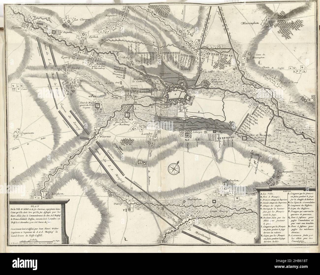